


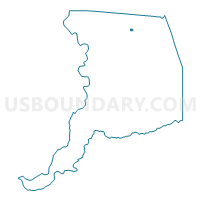
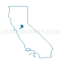
Voting District 41069, Sacramento County, California
About
Outline

Summary
| Unique Area Identifier | 538445 |
| Name | Voting District 41069 |
| County | Sacramento County |
| State | California |
| Area (square miles) | 0.28 |
| Land Area (square miles) | 0.28 |
| Water Area (square miles) | 0.00 |
| % of Land Area | 100.00 |
| % of Water Area | 0.00 |
| Latitude of the Internal Point | 38.65977840 |
| Longtitude of the Internal Point | -121.28670370 |
Maps

Graphs
Select a template below for downloading or customizing gragh for Voting District 41069, Sacramento County, California


Neighbors
Neighoring Voting District (by Name) Neighboring Voting District on the Map
- Voting District 30913, Sacramento County, CA
- Voting District 30919, Sacramento County, CA
- Voting District 40997, Sacramento County, CA
- Voting District 41018, Sacramento County, CA
- Voting District 41072, Sacramento County, CA
- Voting District 41099, Sacramento County, CA
- Voting District 41105, Sacramento County, CA
Top 10 Neighboring County Subdivision (by Population) Neighboring County Subdivision on the Map
Top 10 Neighboring Place (by Population) Neighboring Place on the Map
Top 10 Neighboring Unified School District (by Population) Neighboring Unified School District on the Map
Top 10 Neighboring State Legislative District Lower Chamber (by Population) Neighboring State Legislative District Lower Chamber on the Map
Top 10 Neighboring State Legislative District Upper Chamber (by Population) Neighboring State Legislative District Upper Chamber on the Map
Top 10 Neighboring 111th Congressional District (by Population) Neighboring 111th Congressional District on the Map
Top 10 Neighboring Census Tract (by Population) Neighboring Census Tract on the Map
- Census Tract 81.19, Sacramento County, CA (5,668)
- Census Tract 79.04, Sacramento County, CA (4,797)
- Census Tract 81.38, Sacramento County, CA (3,568)
- Census Tract 80.07, Sacramento County, CA (3,151)
- Census Tract 81.37, Sacramento County, CA (2,432)